
Wildfires, Closures & Restrictions
Let Northwest Portal help you keep up-to date on the latest conditions!
Fire Season 2026
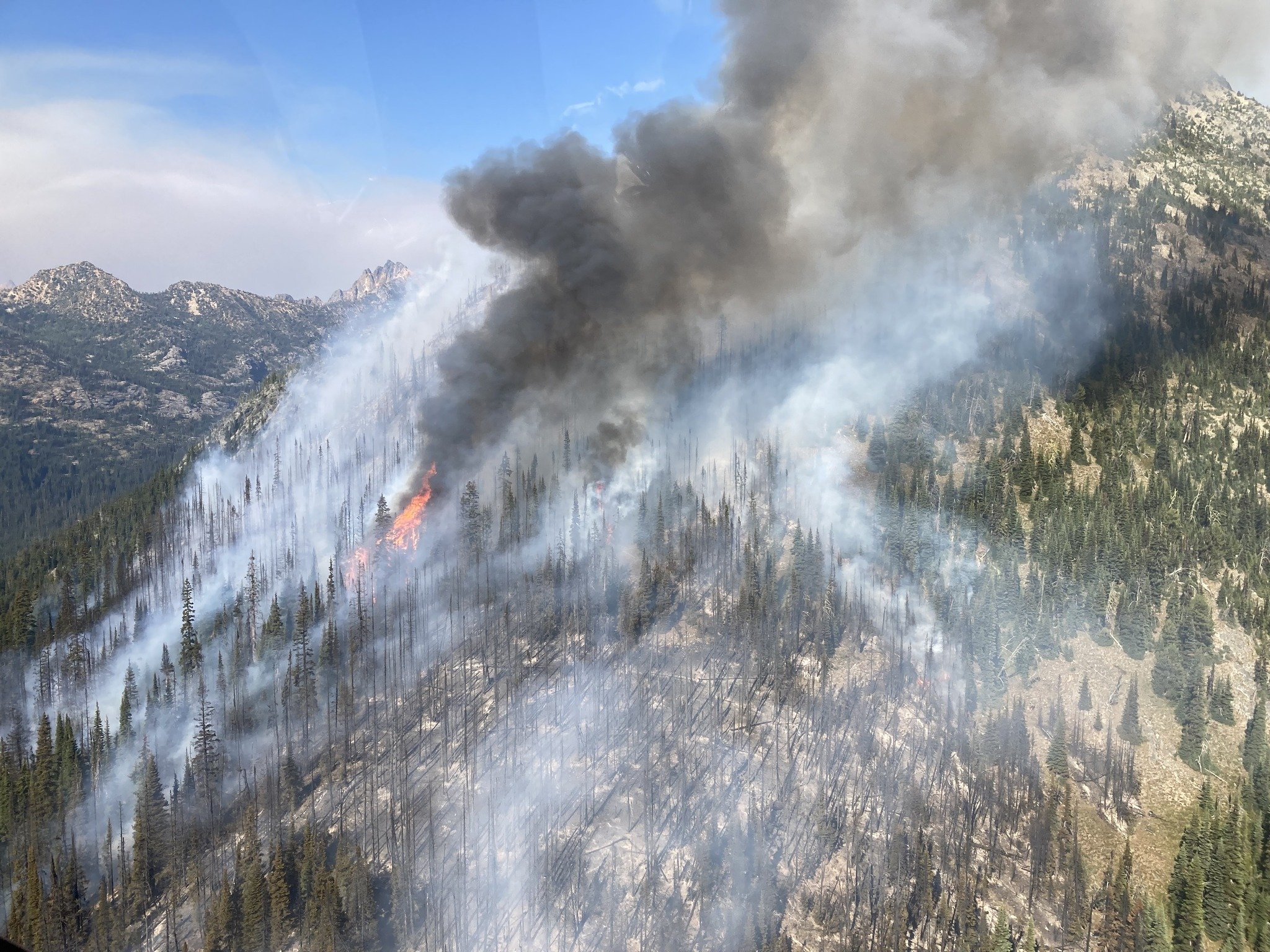
Washington State’s 2026 fire season has started. Find maps showing the latest fire activity detected from satellites, details on larger fires, and current status of closures and burn bans.
Fire activity deteced by the NOAA VIIRS satellites. This provides an approximation of current fire activity, but not all fire activity is detected by these satellites. Fire perimeters are as mapped by the National Inter-agency Fire Center and represent the maximum extent of the fire. These maps are offered under an open license. For a custom map email: contact@northwestportal.com.
Fire Maps
Over the course of the fires season, Northwest Portal has been making regular maps of fire activity. You can download any of the maps from our Dropbox portal.
Latest Maps of fire activity
Maps are not updated if there is no activity within the previous 48 hours and maps are removed once fires are fully contained.
You can maps from the full season from our Dropbox portal.
2026 Fire Details
Updated 7/21/2026
Major Fires in Washington State in 2026
Fires that are reported on Inciweb, the inter-agency all-risk incident information management system run by the USFS.
Active Fires on Inciweb (Less than 80% contained)
Little Giant Fire is north of Lake Wenatchee in Chelan County. It started on 7/15/2026. As of 7/21/2026, it was 400 acres and 0% contained.
Kaiser Canyon Fire is on the Colville Reservation in Okanogan County. It was started by lightning on 7/16/2026. As of 7/21/2026, it was 68,498 acres and 0% contained.
Modrite Fire is on the Eastern edge of the Colville Reservation, on the Columbia River. It was started by lightning on 7/17. As of 7/20 it was 7,919 acres and 0% contained.
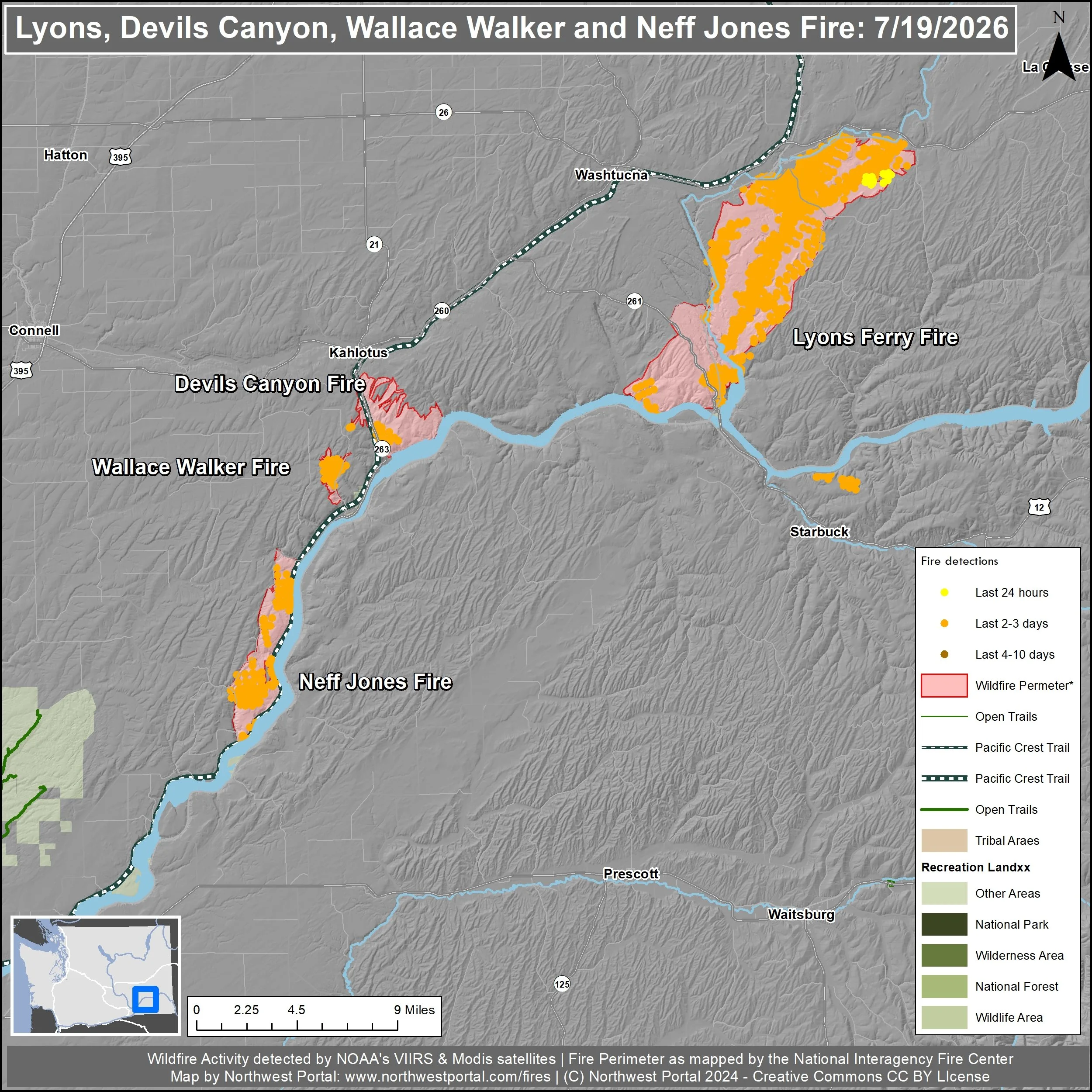
Lyon’s Ferry Fire is at the junction of Whitman, Adams and Walla Walla County. It started on 7/16. As of 7/21 it was 34,011 Acres and 53% contained.
Paradise Fire is in Umatilla National Forsest on the Washington-Oregon border. It was started by lightning on 7/16/2026. As of 7/21/2026, it was 453 acres and 0% contained.
Other fire activity and fires more than 80% contained.
The following fires are more than 80% contained or were not reported on Inciweb.
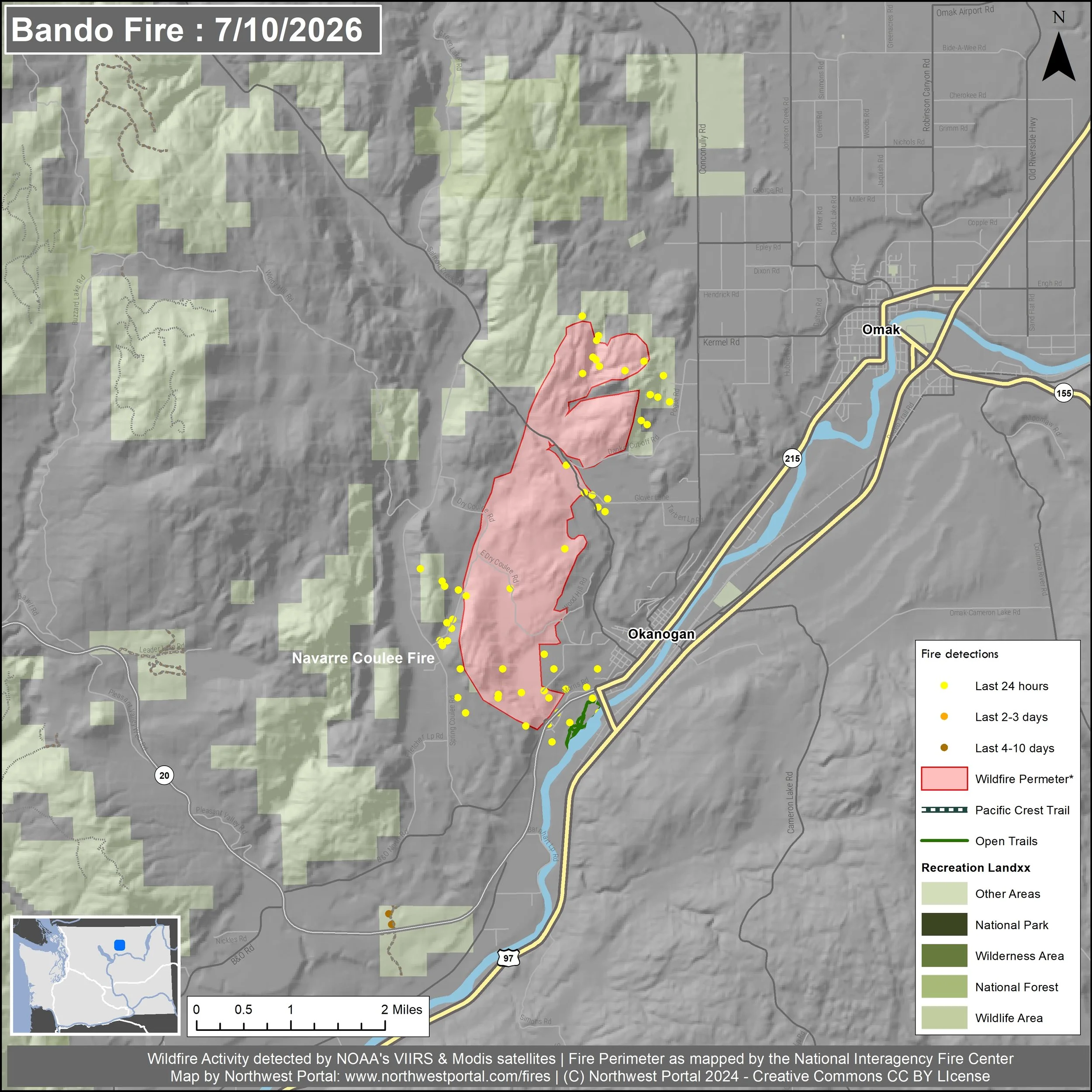
B and O Fire in Okanogan County near Omak. The fire was started on 7/9/2026; As of 7/13/2026, it was 2,762 acres and 95% contained.
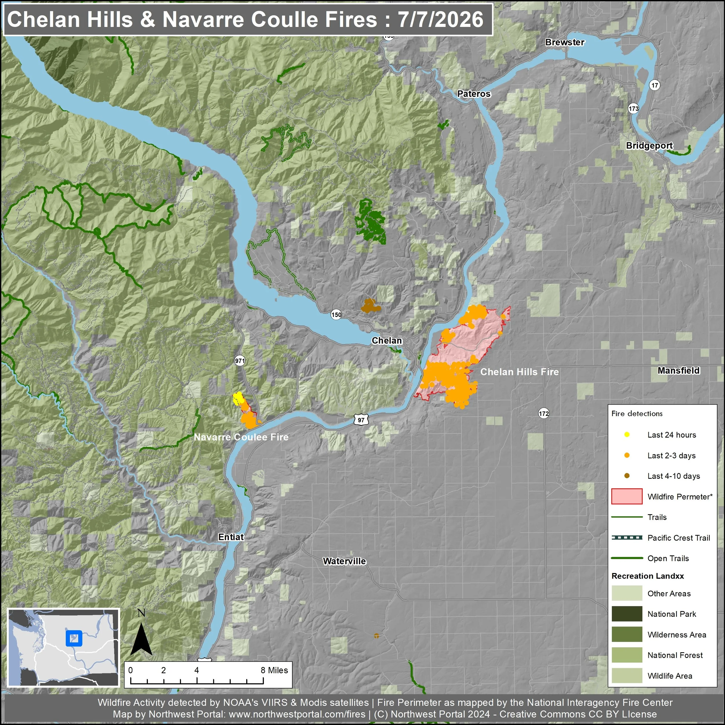
Chelan Hills Fire in Douglas County, near Chelan. The fire was started on 7/4/2026; the cause is currently undetermined but it may be human caused. As of 7/10/2026, it wa 9,861 acres and 95% contained.
Mount Tom Creek Fire in Olympic National Park. The fire was started by lightning on 6/23/2026. As of 7/10/2026, it was 69 acres and 27% contained. The Inciweb page has not been updated since 7/10 and there is no fire activity visible on the NOAA satellite data as of 7/17/2026.
Devils Canyon fire, Lyons Ferry Fire and Neff Jones Fire are in in Franklin County, northwest of Richland. They started on 7/16. As of 7/19 they were all over 88% contained.
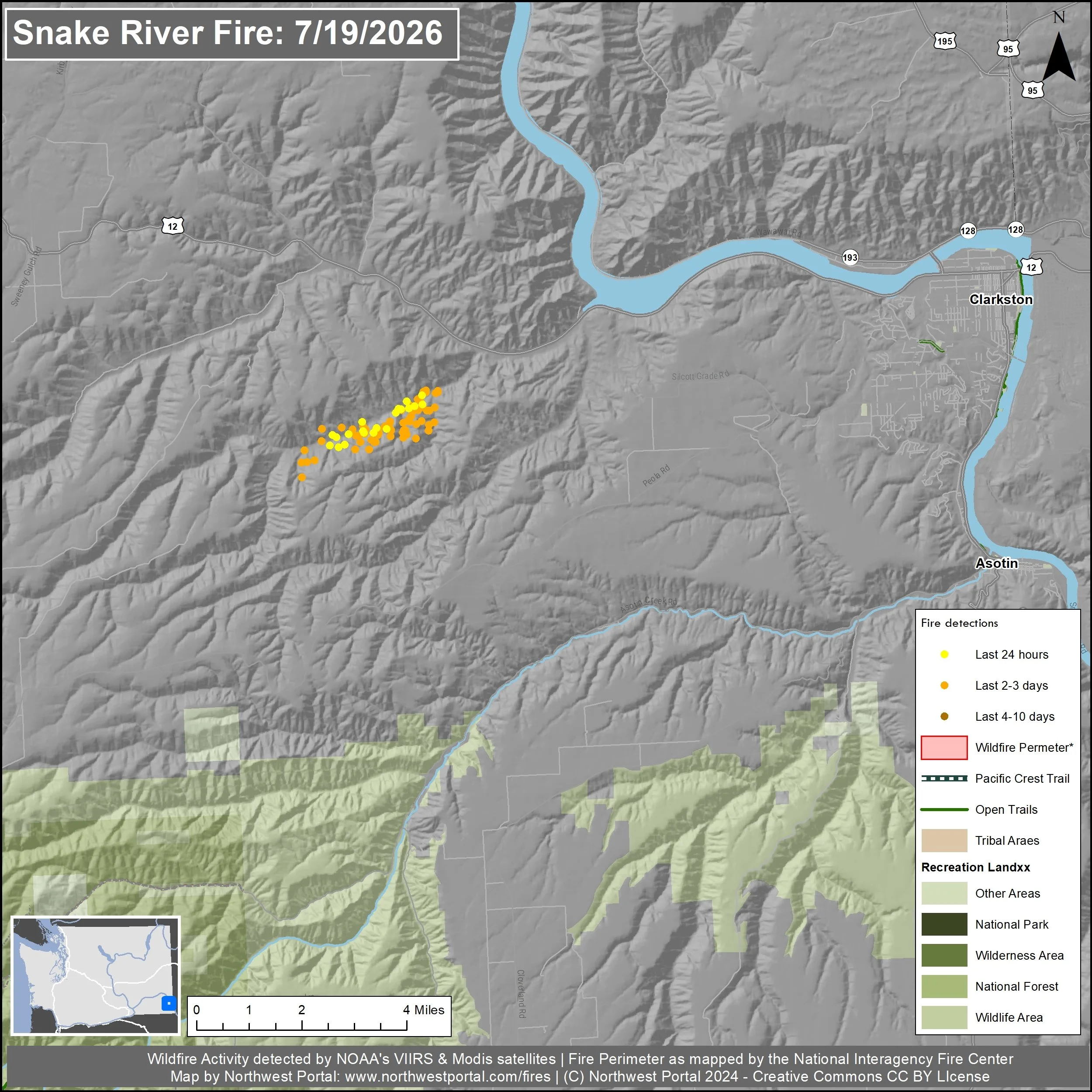
Snake River Fire is in Asotin County. It started in June and is 100% contained.
Royal Lake Fire is south of Potholes Reservoir in Grant County. It started on 7/16. As of 7/21 it was 2,037 acres and 95% contained
Watch Duty, a non-profit, tracks all reported fires and provides information on firefighting efforts in real time.
Final map for fires that are more than 80% contained
-
![]()
Chelan Hills, Douglas County
-
![]()
B & O Fire, Okanogan County
-
![]()
Snake River
-
![]()
Lyons Ferry, Devils Canyon, Wallace Walker & Neff Jones. Franklin County
Fire restrictions:
Campfire Status as of 7/17/2025:
National Forests:
Stage 1 restrictions are in place for the Tonasket Ranger District in Colville National Forest. In Stage 1, open fires are not allowed outside of designated campgrounds with established fire rings or grills
Stage 2 restrictions are in place for Gifford Pinchot National Forest and Okanogan-Wenatchee NF. In Stage 2, all open flames including wood, wood stove and charcoal briquette stoves are prohibited forest wide, include campfires. The use of pressurized liquid gas stoves are permitted in areas that are barren or cleared of overhead flamable material. Smoking is not allowed except in an enclosed vehicle or while stopped in an area that is cleared of all flamable material.
Campfires are banned
Campfires are only allowed in approved designated campgrounds in Gifford-Pinchot National Forest (which aligns with the WA DNR fire rules) and Umatilla National Forest (which is in Phase B).
Campfire restrictions are not in place as of 7/17/2026 for Colville National Forest (outside of the Tonasket Ranger District), Olympic National Forest,
National Parks:
Campfires and charcoal briquettes, including BBQ grills, are prohibited in Mount Rainier National Park and all portions of the North Cascades National Park Service Complex including the Park, Ross Lake National Recreation Area and Chelan National Recreation Area. Gas or propane stoves are allowed as long as there is no flammable material within three feet of the device.
Olympic National Park is not listing any fire restrictions on its home page.
Bureau of Land Management:
Stage 1 fire restrictions on BLM lands in Western Washington and Stage 2 restrictions are in effect in Eastern Washington. Campfires, including charcoal briquettes, are only allowed within provided steel rings at improved campgrounds in the Patos, Posey and Blind Island in the San Juan National Monument, and are banned on all other BLM lands. Liquefied and bottle gas stoves are permitted as long as they are used in area at least 10 feet in diameter cleared of all flammable material. In addition, Smoking is not allowed while traveling in timber, brush or grassy areas if you are not in a closed vehicle. In addition, driving off developed roadways is banned, and vehicles must be parked in an area barren of flamable material.
State Agencies:
WDFW: Fires are not allowed on WDFW managed lands in Eastern Washington, including in fire rings. Personal camp stoves and lanterns fueled by propane, liquid petroleum, or liquid petroleum gas are allowed. In addition, target shooting is only allowed at official shooting ranges from sunrise to 10am and is not allowed at all after August 16th. Smoking is only permitted in an enclosed vehicle, and you cannot operate a motor vehicle off a developed roadway.
WDNR: Check the WNDR burn restrictions map for the current rules in your area.
Counties:
Check your county for latest fire restrictions. As of 7/10 the following counties have county wide campfire bans, but bans may be in place in other counties.
Chelan County: Stage 2 fire level: no residential campfires. Propane/pressurized gas stoves are allowed, charcoal only permitted in commercially made bbqs.
Kittitas County: A burn ban is in effect for all fire districts, no out door burning including campfires. Propane, briquette and pellet appliances are allowed at this time.
Yakima County:
Okanogan County: A burn ban is in effect for all fire districts, no out door burning including campfires.